אינריץ אקספלורר משומש
מסנג'ר לוויני כולל מפות טופוגרפיות
1850
₪
מכשיר ומנוי
Inreach Explorer is recommended for those who travel on foot and want ease of use and a strong battery at a price of 100 grams more than the Inreach Mini
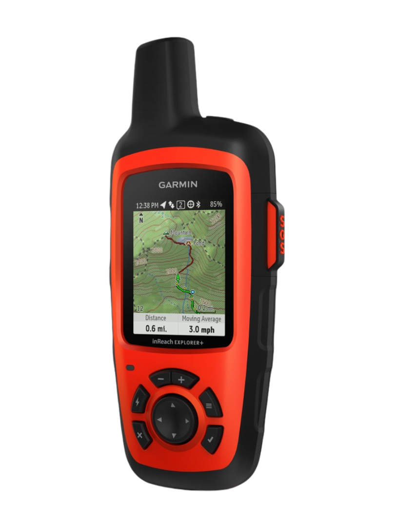
Inreach Explorer Plus is a reliable and powerful device with advanced navigation capabilities that include topographic maps and a barometric altimeter
One device that does everything with simple and easy operation from the device itself without the need for a smartphone
Extremely powerful battery
Download topographic maps and routes to the device
Enhanced navigation data with a barometric altimeter
Navigation to the point even in zero visibility conditions
עלויות
mum rent - NIS 148
Communication costs:
As part of a basic rental, 5000 baht per month is included
Additional usage cost - NIS 50 for each additional 1000 bytes
Data usage up to 5000 bytes per month. You can also use it beyond and at the end of the rental you will be charged for the excess use according to the price list.
Using 5000 bytes includes, for example, about 300 specified or tracking messages, 30 text messages, 50 weather forecasts
Message check, tracking location, predefined message = 15 bytes
Easy basic weather forecast - 100 bytes
Personal text message typed (incoming or outgoing) 100-200 bytes
אודות
A GPS device for satellite communication with a map for orientation.
Suitable for those who want satellite communication with map capability for orientation that is convenient to use even without a smartphone.
If you are looking for a small and light device but without a map, then Inritz Mini will suit you:
general description:
Inritz is a series of GPS devices that enable two-way satellite communication (both sending and receiving) based on text messages.
The device works in the Iridium satellite network and provides full global coverage including the poles.
All devices in the Inritz family include:
emergency button.
Built-in predefined messages that are automatically distributed to distribution lists by email or text.
Option to send and receive free text messages.
navigation capabilities
Inritz Explorer - unique features
Inritz Explorer is equipped with an extremely powerful battery that, when used judiciously, can last even a month of daily use without recharging.
The device can display a location and navigate based on accurate topographic maps that in many places include trail markings.
A barometric altimeter makes it possible to know the height accurately.
Color display monitor 4.7 x 3.5 cm with a resolution of 200 x 265 pixels.
Clear and easy to use menu.
More about this source textSource text required for additional translation information
Send feedback
Side panels
מפרט טכני
Technical data:
- Dimensions: 164*68*38 mm
- Weight: 213 gr
- Temperature range: -20 to +60
- Screen resolutions 200X265 pixel LFT
- Rechargeable battery allows up to 30 days of activity with sending a message every 30 minutes without charging
- Waterproof (IPX7), dust and drops (MIL-STD-810) with IPX7 floatation ability
- Full global coverage on the Iridium network
- Memory - 2 GB for loading free topographic maps
- Option to connect to the Garmin EARTHMATE app,
- Bluetooth connectivity
- Save 500 waypoints and 20 routes
- Sensors - Iridium satellite transmitter receiver, GPS, compass, Gypias compass when in motion, barometric pressure gauge
- Navigation from point to point and navigation back along a route
קבוצת תמיכה בווטסאפ
Do you have any more questions?
Leave your details and we will get back to you as soon as possible.